
월간 환경과조경 검색 결과
선택 조건으로 총
1,645개의 게시물이 검색되었습니다.
- 카테고리: WORK
-
 디큐브시티Landscape Architect _ Oikosdesign landscape + architectureConstruction _ DAESUNG Engineering & ConstructionLandscape Construction _ CORYO Landscape Architecture Co., Ltd, DAESAN L&C, HANSEL…
 -
-
-
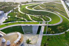 South Pointe Park 다양한 도시 공원 프로그램과 지역 정원, 회복된 자생 서식지의 통합, 그리고 도심 동선체계와의 연결을 통해, 그동안 잘 이용되지 않던 이 공원은 새롭게 재생되어 주변과 지역의 명소로 변모했다. 도시와 크루즈선의 뱃길과 해변이라는 세 양상을 결합하여 문화적, 프로그램적, 환경적 요구사항을 중첩시키는 해결책을 통해 앞으로…
 -
Missouri Korean War Veterans Memorial 2011년 9월 미주리주 캔자스 시티(Kansas City, Missouri)에 위치한 워싱턴 스퀘어 파크(Washington Square Park)에서 치러진 헌정 행사를 통해 미주리 한국전 참전용사 메모리얼(Missouri Korean War Veterans Memorial)이 일반에…
-
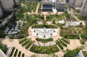 Hwa Myeong Lotte Castle Kaiser 최근 롯데건설(주)에서 시공한 화명 롯데캐슬 카이저는 새로운 개념의 GREEN COMMUNITY를 선보이며 도시 안에 살아 숨 쉬는 자연숲을 조성하여 주목을 받고 있다. 5,239세대의 대규모 아파트 단지는 사직야구장 5개를 지을 수 있는 대지면적에 녹지율 41%를 자랑하는 대단위 조경면적으로,…
 -
 Samsung Engineering’s Global Engineering Center삼성엔지니어링의 신사옥인 글로벌 엔지니어링 센터는 27,604㎡의 대지에 지상 15층, 지하 4층, 건축연면적 186,023㎡로 국내 오피스 건축물 중 5위에 해당하는 초대형 건물로 미국 HOK사와 삼우종합건축사사무소에서 설계하고 삼성엔지니어링이 직접 시공하였다.건축물…
 -
-
-