-
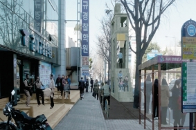 2011광주디자인비엔날레 어반폴리 프로젝트
디자인으로 채워지는 광주, 시민들의 참여로까지 이어져2011광주디자인비엔날레는 도심 재생 및 세계적 디자인 도시로서의 기반 구축을 위해 추진하는 어반폴리Urban Folly 프로젝트의 구체적인 디자인 시안들을 공개하였다. 이 행사는 광주 시내에 총 10곳의 폴리Folly를 선정하여 도시 내의 장소에 대한 개념을 회복하는 기회를 제공하고 사람들로부터 그들의 환경에 대한 적극적인 참여를 유도하여 낙후된 광주 시내를 재건하는데 도움을 주는데 목적을 두고 있다. 승효상과 아이웨이웨이가 공동 감독을 맡았으며, 장동 교차로, 제봉로 김재규 경찰학원 앞, 대한생명 사거리, 충장로 파출소 등 9곳이 폴리로 선정되었다. 광주세무서 앞 사거리는 (국제)현상 설계 공모 당선작으로 대체하였다. 당선작에는“열린 장벽”의정세훈, 김세진(오우재 건축사사무소)이 선정되었다. 건축가들은 보고회를 통해 어반폴리 작품 디자인과 작품 해설을 시민들에게 직접 설명하기도 하면서 한국의 도시 환경 정비 사업 방법의 미래를 토론하는 기회도 가졌다. 본 고에서는 10곳의 어반폴리를 자세히 소개한다. 편집자주
자료제공_광주비엔날레 재단
-
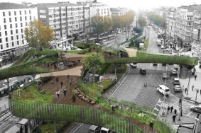 보행자 전용 다리 설계 경기에 대한 새로운 비전
New Visions for Pedestrian Footbridge Design Competition보행자 전용 다리는 이스탄불에서 가장 번화한 구역 중의 한 곳에 위치하고 있는데, 중심지에서 역사적인 반도쪽으로의 축으로 이어져 있었다. 이 축은 중간에 배치된 트램노선으로 인해 교통 부하가 걸리는 중요한 부분으로 드러났다. 그 때문에 이 보행다리는 이 지역 내 교통 수단의 가장 중요한 교차로의 역할을 하며 보행자의 이동을 해결하는 수단이 되었다.보행자들의 움직임이 이루는 축은 디자인을 결정하는 전략적인 요소가 되었다. 이러한 요소들은 트램역의 동쪽과 서쪽에 있는 횡단보도에 의해 서로 연결되어 있고 중앙의 보행자 전용 다리 옆의 역으로 연결된다.필요로 하는 보행자 전용 노선은 도시 전략의 기준으로 여겨지는 시간대별에 의해 만들어 진다. 차량 교통을 통제하면서 요구된 보행자들의 행태를 위한 최소한의 구역이 결정되었다. 이 구역은 공중으로 6m 올려 상업적이고 문화적인 행태에 의해 형성된 보행자들의 광장을 강화시켰다. 광장은 또한 주변 거주자들을 요구로 작은 규모의 공원으로 변형되었다. 주변 환경으로부터 이곳저곳이 고립되었기 때문에 축이 시각적 깊이를 더해주는 연결 고리 역할을 하고 있다.
구조물의 콘크리트 상판은 보강 콘크리트 기둥이 지지하고 있는 상부에 놓인 철제 빔에 의해 받쳐져 있다. 콘크리트 상판을 둘러싸고 있는 벽의 높이는 철제 프레임 빔에 의해 형성되는데 이 빔들은 장소에 맞게 조정되어 있다. 이러한 빔들은 또한 넓은 바닥판의 안정성을 유지해준다. 엘리베이터 주변의 철근 구조물은 수직적인 수송 체계를 지탱하고 있다.
The footbridge is located in one of the busiest districts of Istanbul. It holds the main axe connecting the center to the historic peninsula, baring an important portion of the traffic load, with the tram route taking place on the middle. Therefore, it covers the most important crossroads of vehicle and pedestrian movement in the region.
The axial movement of the pedestrians are taken into account to determine the strategic points for the design. These points are connected to each other by the pedestrian crosswalks on the east and west sides of the tram station and connected to the station by the footbridge at the middle.
The desired pedestrian routes established by time constitute the basis of the proposed urban strategy. Eliminating the vehicle traffic, the minimum area for the desired pedestrian motion is determined. This area is lifted 6 meters into the air and is enriched to be a pedestrian square by commercial and cultural activities. The square is also been transformed into small-scale park as needed for the surrounding settlements. As it isolates itself from its surroundings from place to place, it is linked where the axes expose the depth of perspective.
ConstructionThe concrete floor plate of the structure is carried by the steel beams resting on top of the reinforced concrete columns. The heights of the walls sorrounding the concrete floor plate is formed by the steel frame beams that will be adapted in place. These beams also maintain the stability of the wide floor plate. The steel constructions around the elevators also help support the vertical carriers.Designer _ LEA Invent (Lorenzo Sangiorgi, Emir Drahsan, Alexandre Schrepfer) & Burcak PekinStructure _ Grohmann & BollingerCollaborators _ Erkan Goray, Ugur Seymen (Yapi Akademisi), Charlotte CoteClient _ Istanbul CityLocation _ Fatih Vatan Street, Istanbul, Turkey
-
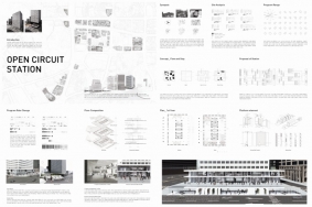 건물 전면 매력적인 문화 휴게 공간 만들기 학생 아이디어 공모전
도심 속 시민들의 커뮤니티 활성화 기대..서울시는 지난 3월 8일(화) ‘건물 전면 문화 휴게 공간 만들기’공모전 수상작을 발표하였다. 이번 공모전은 사단법인 도시가꿈과 공동 주최한 것으로 일반 시민들에게는 공공 공간을 제공하고, 기업에게는 사회 참여를 유도하고자 하였다. 박항섭 경원대 교수를 심사위원장으로 한 심사위원회는 건축·도시, 조경·디자인, 언론·건물주로 구성하여 다양한 시각에서 심사가 이루어지도록 하였다. 시상은 대상 1점, 우수상 3점, 장려상 6점, 기타 입선작이 선정되었다. 대상으로 선정된 Open Circuit Station은 서울 태평로 삼성 본관 1층과 주변 공간에 대한 전반적인 리모델링을 제안한 것이다. 인도에 산재한 가판대와 버스 정류장 등을 한 곳으로 모았으며, 건물 주변으로 녹지를 조성해 시민들의 소공원으로 이용할 수 있도록 계획하였다. 특히 본관 1층의 벽을 투명 유리로 바꿔 시원한 느낌을 주었으며, 실내에는 카페와 전시 공간 및 지하 상가 연결 통로를 만들어 눈길을 끌었다. 편집자주대상 Open Circuit Station 김정현, 안성현, 홍연경(중앙대 건축학과)자료제공_ 서울시 도시개발과
-
 경기농림진흥재단 녹화사업부
경기농림진흥재단은경기도는 2003년 8월 경기도 녹화 종합 계획인 ‘푸른경기 Green 프로그램21’을 마련하였다. 이 계획을 성공적으로 실천하기 위한 핵심 추진 주체로서 민·관이 파트너십을 이루어 2005년 4월 (재)경기녹지재단이 출범하게 되었으며, 경기도 농업 활성화 및 도민의 소득 증대에 이바지하기 위해 농특산물 소득 및 유통사업이 추가됨에 따라 2007년 7월 (재)경기농림진흥재단으로 명칭이 변경되었다.경기농림진흥재단은 이사장, 대표이사, 1실 3부 1단위의 부서로 구성되어 있으며, 이사장은 현재 경기도 행정1부지사를 겸임하고 있는 최홍철 이사장이, 대표이사는 가평부군수 및 경기도 환경정책국장을 역임한 민기원 대표이사가 맡고 있다. 그리고 이번 호 ZOOM IN GROUP에 소개하는 녹화사업부는 최연철 부장, 오강임 과장, 김용훈 대리, 최문선 주임으로 구성되어 있다.
녹화사업부가 하는 일경기농림진흥재단 녹화사업부에서 담당하고 있는 사업은 옥상 녹화, 자투리땅 녹화, 담장 녹화, 벽면 녹화 등의 도시 녹지 조성 사업, 숲체험학교 및 조경가든대학 등의 교육사업, 정원 문화 확산을 위한 경기정원문화박람회, 버려지는 수목을 재활용하는 나무은행 사업 등으로 구분할 수 있다.이 중 2011년 주요 사업으로서 옥상 녹화 지원 사업, 조경가든대학, 제2회 경기정원문화대상, 나무은행 등이 현재 추진중에 있다.
경기농림진흥재단에서는 생활 속의 정원 문화 정착 및 경기도 브랜드 가치를 제고하기 위해 2010년 경기정원문화박람회 개최를 시작으로 정원 문화 확산을 위한 다양한 사업 및 행사를 추진 중에 있다. 특히 2006년 제1회 아름다운 정원문화대상의 연장인 2011년 제2회 경기정원문화대상을 6월에 개최할 예정이다(3월 14일부터 4월 17일까지 공모).이 사업은 콘크리트로 둘러싸인 도시를 푸르고 아름답게 만드는 우리 주변의 개인 주택, 아파트, 건물, 공장의 정원을 찾아, 시상 및 격려함으로써 정원 문화를 확산하고자 한다. 이러한 사업 과정 속에서 개인을 비롯한 관련 단체, 전공 대학생, 관련 전문가, 지자체 등이 함께 참여하는 장을 만들고 도시 녹화 활성화 및 자발적 참여에 중요한 역할을 할 것으로 기대된다.이러한 취지에서 제2회 경기정원문화대상에 많은 관심 및 홍보가 필요로 하며, 독자 여러분의 적극적인 응원과 지지를 부탁드린다.
-
 구조로 보는 조경이야기(8)
여덟 번째 이야기: 쓰기 위해 읽는다
설계라는 맥락적 게임당연한 사실이지만 많은 의견의 조정들이 이 안에서 같이 이루어진다. 발주처의 요구 사항도, 프로그램도, 내가 하고 싶은 이야기도 모두 거기에 같이 태운다. 그러다보니 돌발 변수도 참 많다. 설계란 참으로 힘들면서도 재미있는 작업인 것이 이들을 가지고 잘 버무려서 하나의 parti로 완성해야 하는 것이므로, 전체적인 사고, 부분적인 사고, 어제와 오늘, 갑과 을의 이야기가 모두 한 그림 안에서 어우러져야 하고, 그러기에 고도의 줄타기 테크닉 역시 필요하다.이런 판국에 본인이 하고 싶은 이야기조차도 스스로 정립이 안 되어 이곳저곳의, 심지어는 스스로의 변덕에 휘둘리는 것에 설계를 맡겨버린다면, 결국은 우리의 설계는 항상 힘들며 진공상태를 경험할 수밖에 없다. 어쩌면 우리는 그렇기에 지난 연재에서 이야기한 바와 같이 새로운 설계 이론들이 나올 때마다 쉽사리 몸을 내어준 것인지도 모른다. 내 설계의 근거를 외부에서 찾는 것이기 때문에 그것들이 잠깐의 동력은 될 수 있겠지만 결국은 언어를 위한 언어, 다시 말해 메타언어일 뿐이므로 영영토록 우리 설계의 내적 준거로 삼을 순 없다.윤동주의 서시를 해석하면서 느꼈던 것, 좋은 시란, 어려운 단어 하나 없이 편안하게 효과적으로 명징하게 감흥을 잘 전달하는 것이라는 것처럼 좋은 설계 역시도 마찬가지이다. 사공으로 가득한 직관과 영감의 바다에서 내적 준거를 확실하게 잡고 본인의 설계 언어로 형태와 공간을 명료하게 마름질해나가는 것이 우리 설계가의 내공인 셈이며, 그러므로 어찌 보면, 구조로 보는 조경이야기는 우리 개개인이 벌이는 맥락적 설계라는 본인 스스로 감내해야 하는 초인의 세계에서 내공을 기르기 위한 노력이라 할 수 있겠다.연재의 초반에 얼핏 언급한 바 있는 설계 프로세스에 관한 이야기를 이제 마저 할 수 있을 것 같다. 그 당시에는 어마어마한 주제가 막연히 막막하기만 해서 미로 같은 이야기는 이쯤에서 관두자며 덮어두었던 것이 떠오른다. 연재를 끌어오면서 많은 이야기들을 했는데, 이제 거기에 뜰채를 담가 건져보면 기억나는 대로 대략 다음과 같은 키워드들이 건져질 것만 같다. 아마 여러 번 반복하여 말한 것들이어서 독자 여러분의 귀에도 많이 익은 단어들 일듯하다.“전체상, 요소, 전체, 속성, 관계, 체계”
기억하다시피, 이것들은 구조로 보는 작품 읽기의 핵심 사항들이었던 것으로, 설계라는 것이 나의 이야기를 쓰는 것이므로 그 창조적 측면에 무게를 두어 위의 단어들을 한 문장으로 묶는다면 설계란, “요소라는 부분을 여러 체계로 이루어진 전체 안에서 하나의 완성된 구조를 만드는 과정이다.”라고 정의할 수 있겠다. 읽기나 쓰기나 맥락적 사고라는 점에서 그 둘은 매양 똑같은 구조주의자의 사고 활동이다. 읽기라는 작품 해독은 요소를 분해하여 그 속성이 전체와의 연계성을 어떻게 만드느냐를 해독하는 과정이고, 쓰기는 요소와 부분을 가지고 반대로 능동적으로 전체를 구축하는 것이므로 방향은 다르지만 같은 연장을 들고 가는 셈이다.
여기에 한 가지 덧붙이자면 우리가 설계라는 쓰기를 할 때에 조차도 읽기라는 행위는 언제나 항상 수반된다는 것이다. 우리의 작업을 스스로 읽어서 다시 고쳐 쓰는, 부단한 자기 참조적인 과정을 통해서 설계가 앞으로 나 아가기 때문이다. 맥락적인 사고의 계 안에서 이쪽 방향과 저쪽 방향을 종횡무진 달려가며 피드백을 해가는 읽기와 쓰기의 반복행위, —이 안에서 읽기의 대상은 사이트의 조건이 될 수도 있고, 혹은 그것을 바탕으로 나온 본인 스케치 자체일 수도 있겠다—이것이 바로 설계, 그 직관의 세계에서의 우리 디자이너라는 이름의 초인들이 하는 게임이 아닐까?
-
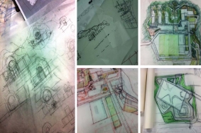
 경상북도 본청 및 의회청사 신축 공사 턴키 프로젝트
경상북도는 지난해 10월 ‘경상북도 본청 및 의회청사 신축 공사’ 입찰 공고를 냈다. 안동시 풍천면과 예천군 호명면 일대에 건설될 경북도청 이전 신도시의 랜드마크가 될 경북도청 신청사는 설계·시공일괄입찰 결과 지난 2월 22일 CA조경기술사사무소가 참여한 대우건설 컨소시엄이 설계와 가격 점수 등 종합 점수에서 1등을 차지해 최종 시공사로 선정되었으며, 오는 5월 공사에 들어가 2014년 6월 완공될 예정이다. 이에 당선작을 조경 계획을 중심으로 소개한다.
1등작 _ 한울지움(주)대우건설+희림건축+동우이앤씨+금성건축+CA조경기술사사무소조경설계참여자 _ 진양교 대표, 김재환, 정원령, 안성순, 한유진, 이세환, 정미영, 이희주, 권민석
-
 마운트 로열 파크 필 엔트런스 재개발
Redevelopment of Peel Entrance, Mount Royal Park역사와 생태학의 통합1874년 옴스테드(Frederick Law Olmsted)가 설계한 마운트 로열 파크는 연간 오백만 명 이상의 방문객이 이용한다. 이 공원의 복원계획 이전, Peel 섹터에는 부스러지는 벽체와 허물어진 계단, 진흙투성이의 좁은 길만 남아 있어 공원과의 연계가 취약하고 황량한 느낌을 주고 있었다. 그럼에도 불구하고 이 공원의 자연스럽고 그림 같은 경관은 여전히 옴스테드의 작품의 시적인 형태로 알려져 있었다.
옴스테드의 전통성을 유지한 채로, 이 산이 가진 고유의 특성들을 지역 재개발과 재설계에 이용하였다. 지질학적 및 수문학적 다양성과 식물의 다양성(풍부함)을 프로젝트에 담고 기존의 자연적이고 문화적인 요소들에 대한 세심한 관리를 시도하며 Peel 섹터가 도시와 견고하게 다시 연결되도록 하였다.
교통 관리순환체계를 위한 구조적인 요소들은 옴스테드의 초기 계획안과 이용 햇수를 고려한 필요 노선들을 둘 다 만족시키고 있다. 이들은 Peel과 Redpath 진입부에 있는 두 개의 장엄한 입구에 대한 재정립, 옴스테드 길의 단면에 대한 개선, Serpentine 길의 재공사, 새로 만든 세 개의 계단들과 나무로 만든 거대한 계단참, 화강석 포장과 화강석 판석들을 포함하고 있다.
물 관리복합적인 생태수문학적 물 관리 전략은 종다양성을 증진시키기 위해 생태계를 활성화시키며, 부지 내를 흐르는 풍부한 표면유거수를 조절한다. 상류 조절장치는 초당 50리터씩 전체 부지에 물을 흘려보내도록 제한하고 있고, 네 개의 습지는 식생과 야생 동물의 다양성을 증진시킨다. 습지대와 배수로는 표면 유거수를 모아주고 집수시설은 물을 배출구로 흘려보낸다. 이들은 모두 연결되어 일관성 있고 자율적인 수문 시스템을 형성한다.Union between history and ecologyDesigned by Frederick Law Olmsted in 1874, Mount-Royal Park has over five million visitors per year. Prior to its restoration, the Peel sector was desolate; a crumbling wall, a stairway in ruins, and muddy pathways; the link into the park was tenuous. Nonetheless, its natural and picturesque character were still informed by the poetics of Olmsted’s work.
In keeping with Olmsted’s tradition, the mountain’s own characteristics were tapped to regenerate and redesign the sector. Tying the project into the geological, hydrological and vegetative richness of the mountain firmly reattached the Peel sector to the city through the careful management of the existing natural and cultural elements.
Traffic ManagementThe structuring elements for circulation respect both Olmsted’s original layout and the desire lines imposed from years of use. These included redefining the two majestic gateways at the Peel and Redpath entrances, the remediation of a section of Olmsted Road, the reconstruction of the Serpentine path, three new staired pathways and numerous landings in wood, granite pavers or granite slabs.
Water ManagementThe complex eco-hydrological water management strategy controls the significant runoff through the site while developing ecosystems which encourage biodiversity. An upstream regulator limits flows for the entire site to 50 litres/sec, four wetlands encourage vegetative and wildlife diversity, swales and gutters intercept runoff, and catchment structures carry the water to the outfalls. The whole is linked together to form a coherent and autonomous hydrological system.
Forest ManagementRaising the ecological value of the woods was the aim of the forest management practice. This included the regeneration of native shrubs, enhancing the avifaunal and micromamellian habitats, creating animal corridors, and insuring the safety of park visitors. This required considerable felling, pruning and planting to control invasive species and to open views towards the Saint Lawrence River and Olmstedian tableaus.
Artist InterventionThis work commemorates John Lennon’s famous bed-in with Yoko Ono in 1969 protesting the Viet-Nam war. At the base of a majestic rock outcropping, 180 rectangular limestone slabs are set flush with the ground carving out a retreat beside the upper curve of the Serpentine path. “Give Peace a Chance”, written and recorded during his Montreal stay, is carved in relief on 40 slabs in 40 languages, offering the public a universal and humanist vision to mirror Montreals cultural diversity.Author _ Cardinal HardyTeam _ Suzanne Rochon, Marie-Claude Seguin, Guillaume Vanderveken, Vanessa Parent, sabelle Giasson, Michele GauthierCollaborators _ Genivar, Denis Marcil ing. forestier, Linda CovitClient _ City of MontrealLocation _ Montreal, Quebec, Canada
- www.cardinal-hardy.ca / 2011년04월 / 276
-
 써니베이
써니베이
Sunny BaySunny Bay는 황해의 서쪽 해안, 즉 산동성 리자오(Rizhao)시 벽해로(Blue Sea Road)동쪽의 2.7킬로미터에 이르는 해안을 말한다. 이 지역의 남쪽에는 보트 항해 게임을 위한 기초 시설과 완코우 수중 공원, 서쪽에는 올림픽 워터파크, 북쪽에는 습지가 있다.이 지역은 전형적인 기복이 있는 해안사구 지역을 포함하고 있다. 동쪽에서 서쪽으로 흐르면서 도시 지역이 분포되어 있으며 벽해로, 해안 저지대의 그린벨트, 높은 모래 언덕과 높은 지대, 낮은 해변과 바다가 있다. 기존 식생은 대부분 곰솔이며, 식물들은 불균형하게 드문드문 분포되어 있다. 시설들 또한 불충분하다.
생태 보전 원리 내에서, 계획안은 해양, 해안선, 식생과 기타 자연 자원 보존을 고려하여 설계했다. 또한 충분히 고려된 작업을 통해 태양력, 풍력, 조력과 기타 자연 자원 같은 생태적 요소들을 이용할 수 있도록 하였다. 자연적, 지역적, 문화적 요소의 반영과 현대적인 체육 시설을 갖춘 휴양 시설을 반영하는데 중점을 두었다. 뿐만 아니라 해변과 바다와의 관계, 해변과 부지와의 관계, 땅과 시설과의 관계 및 오락적 관점과 지자체간의 교통 해결에도 역점을 두고 계획하였다.
전체 부지는 여러 중요한 지역을 포함하고 있는데 이들 지역은 령항 광장, 송도 광장과 성해 광장, 해안선을 따라 위치한 승풍 광장으로 이루어진 네 개의 테마 광장, 푸드 서비스 지역을 포함한다. 또한 오락 시설과 기타 어린이 놀이 시설, 대중목욕탕, 레스토랑 아쿠아틱 센터와 관련 시설 등을 위한 오픈 스페이스 및 기타 여가 생활을 위한 작은 공터 등을 포함하고 있다. 판자를 깔아 만든 길과 자전거 도로는 회해, 망해, 관해, 유해, 범해, 열해, 화해라 불리는 역들을 지나는 통합 교통로와 연결되어 있다.On the west coast of Huang Sea, east of Blue Sea Road in Rizhao City Shandong Province, is Sunny Bay, which has a coastline of about 2,700 meters. On the south side of the site are sail boat game base and Wankou Aquatic Park, to the west is the Olympic Water Park, and in the north are wetlands. The site is a typical undulating coastal dunes topography. Running east to west are an urban area, Blue Sea Road, the lower beach green belt, the higher sand hill & highland, and the lower beach, and finally the ocean. The existing vegetation consists mostly of black pine. The plants are unevenly distributed and sparse. The facilities there are also inadequate.
In keeping with the principles of ecological preservation, the planning incorporated conserved marine, coastal, vegetation and other natural resources. Also fully considering making use of the ecological resources such as solar energy, wind energy, ocean tides and other natural advantages. There was a stress on reflecting natural, regional, cultural, and leisure with a modern aesthetic, as well as a focus on solving the relationship of sea and the beach, beach and site, field and facilities, recreational viewing and municipal traffic.
The whole site has several key areas: the four theme squares of Lianghang Square, Songtao Square, Xinghai Square and Chengfeng Square along the coast, and food service area, the glade providing recreation and open spaces for other functions, such as maze and children’ play facilities, the central service area for bathhouse, restaurants, aquatic center and related service facilities. Boardwalk and bike paths linked the overall traffic roads, along which distributed number of break stations named Huihai, Wanghai, Guanhai and Youhai, Fanhai, Yuehai, Huaihai.
Due to the effects of perennial sea breezes, the growth rates of trees there is very slow, making the preservation and care of all plant material a top priority. For the destructed vegetation, the first step is restoration. Meanwhile rationally plants that can withstand the salinity, wind & tide native plant to complement the vegetation. These plants create a three-layer composite green structure combined with the existing tree belt to build different levels of landscape plants, making the site vegetation more abundant. To protect the original vegetation, the designer placed the buildings within the footprints of the previous buildings and the existing squares, so that no new buildings impacted the existing vegetation. In addition, the landscape boardwalk has been raised to maintain the natural growth of vegetation there. And the wave-type retaining wall and other facilities not only have a recreational function, but also played the role of the second layer of sand bar to prevent wind erosion of the building and block the spread of sand.Design _ ECOLANDLocation _ Rizhao City, Shandong Province, ChinaArea _ 680,000㎡
- www.ecoland.cn / 2011년04월 / 276
-
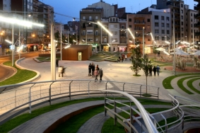 리까르드 비녜스 광장
Seu Vella 성당을 둘러싸고 있으며 도시 전체에서 가장 두드러진 요소인 드넓은 녹지는 Lleida에서 가장 아름다운 공공 공간이자 우리가 기준으로 삼은 공간이다. 새로 만들어진 Ricard Vines 광장은 이 녹지의 아름다움을 반영하려 하였다. 우리 제안의 요점은 음악가 Ricard Vines를 위해 헌정된 조각을 위해 넓은 녹지 공간을 조성하는 것이었다. 이 공간은 도시의 교통과 보행이 모여드는 지점에 0 5 10 횡단도와 녹지 공간으로 이루어진 작은 광장들로 채워졌다.
우리는 중심 시설을 빙 둘러가며 사람들을 마치 봄의 춤을 추는 듯한 모양의 계단으로 이끄는 미로가 있고, 이 미로와 함께하는 무도회장 같은 오픈 스페이스를 제안했다. 춤 동작을 만들어내고 안내하는 형상의 이 중심 시설은 삶을 표현하며 주변 공간을 채우고 있다. Ricard Vines 광장에서 사람들과 차량은 별도로 진입하므로, 이 광장에서 보행자들은 그들만의 공공 공간을 가질 수 있다.
우리는 Calle Roure의 서클 공간을 위한 미로를 설계하였다. 우리는 미로라는 아이디어를 입구에 대한 아이디어로 구현시키고 싶었고, Lleida로 들어오는 도시의 입구는 새로운 녹색 대문이 되었다. 이 프로젝트는 원형으로 구성되어 도시를 위한 새로운 형태의 광장으로 만들어졌다.
이 서클 광장에는 공공 광장에 거주하는 커뮤니티를 위한 조명과 공동의 정체성을 위한 거리 파티라는 컨셉을 강조하는 조명이 설치되어 있다. 이 조명들은 서클의 한쪽에서 시작하여, 넓은 조각 같은 조명 요소들이 전체 광장을 비추고 있다. 원형의 중심에 새로 설치된 조각은 도시의 다른 지역에서부터 두드러진 장소를 만들어주는 랜드마크가 되고 있다.The large green open spaces that surround the Seu Vella Cathedral and dominate the whole city are the most beautiful public areas in Lleida, and are what we chose as our reference point. The designs for the new Ricard Vines Square must possess some of this beauty. The focus of our proposal is to build a large green open space for a sculpture dedicated to the musician Ricard Vines. A space full of little squares 0 5 10 cross section and green areas at a point where the city throngs with traffic and pedestrians. The maze or labyrinth provides an ancient model. The cultural meaning and interpretation of the symbol of the labyrinth run deep. The origin of the “labyr” part of the word has to do with rocks and stone, while the “inth” comes from a Greek word meaning foundation site. Even though the precise etymology is unclear, there was a time when path mapping was used to notate dance choreography.
We propose an open space featuring a dance floor with a labyrinthine path guiding the steps of those dancing the spring dance around the central feature - a feature that generates and guides the movement of the dance, filling the surround space with life. People and traffic will move differently in Ricard Vines Square, where pedestrians will own the public space.
Everyone will follow the paths mapped by the dance notation, but with no overlap. Perhaps the closest reference to our design idea is Francesc Macia Square in Barcelona, in one of the busiest areas of the city, and at a key transit point in and out of the city. Other European cities are famous for the spectacular circles in their metropolises, such as the Etoile in Paris or Berlin’s Tiergarten with its famous column topped by an angel. In the UK, the architect John Wood created one of Bath’s most iconic features with the Royal Crescent whose circular green spaces control the flow, and substantially contribute to defining and propagating the city’s image. Circular spaces are not normally accessible and for this reason are often laid out as parks, regulating traffic flow and giving drivers a glimpse of the natural world.
We have designed a maze for the circular space in Calle Roure. We like incorporating the idea of a labyrinth into the idea of an entrance. The city entrance to Lleida is a new green gate. The project is made up of a circle and new square for the city:
1. The circle ends in a labyrinthine pattern, made up of bands of planting and brick paving.2. The square is split up by green areas; a maze of trees and low shrubs that are visible from the roadway. This greenery helps organise the neighbourhood’s leisure activities with bars, children’ play areas, benches and pedestrian pathways. The two streets that feed into the square will be pedestrianised, using natural stone paving, and they will be softened by new tree planting and small green spaces which will punctuate the entrances to residential buildings. From one side of the circle a wide sculptural light source will illuminate the whole square, underlining both the idea of the community that inhabits a public space and the street party concept as a mark of collective identity. A new sculpture installed in the middle of the circle will become the landmark that makes this place stand out from the rest of the city.Main Partners _ Benedetta Tagliabue(Architect)Chief Architect _ Josep Ustrell, Daniel RossellóClient _ Lleida City HallLocation _ Lleida, SpainArea _ 9,200㎡Complete _ 2010. 11
- www.mirallestagliabue.com / 2011년04월 / 276
-
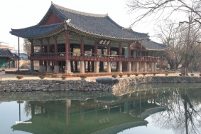 광한루원
광한루원
Gwanghallu광한루원은 전라북도 남원시 천거동 78번지 일원에 위치하며, 조선 세종 원년(1419) 황희黃喜가선조인 황감평黃鑑平이지은일재라는 서실을 헐고“광통루”라는 누정을 지은 것에서 연유한다. 현재 약 69,795㎡ 일원에 광한루를 중심으로 월랑, 영주각, 방장정, 삼신산, 오작교 등에서 자연과 인공이 화합하는 순응의 미학을 공간적, 지형적으로 연계시키고 있다. 또한 성리학적 세계관, 음양오행, 풍수지리사상 등이 내재된 신선의 세계관과 천상의 우주관을 표현하고 있어 공공 원림으로서의 누원 분야의 좋은 연구 자료로 평가받고 있다. 2008년 1월 8일 사적 303호해제와 동시에 명승 33호로 지정되었다.