-
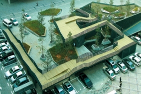
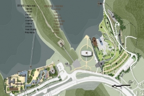 Memorial: 이순신 순국 공원
프로젝트를 통해 보는 Landscape Design Process기념 공간을 새로이 조성할 때, 주된 과제는 아마도 역사적 인물이나 사건 등 직접 눈으로 볼 수 없는 대상을 공간적 언어로서 구체화하는 것일 것이다. 개인적인 추억이나 추모는 직접적 대상이 없어도 기념품, 사진 등을 통해 이루어지지만, 사회적 규모의 기념 공간에서는 이처럼 이용자가 연관지을 수 있는 간접 대상조차 없는 경우가 많기 때문이다. 이를 해결하는 가장 쉽고 직접적인 방식은 그러한 대상을 재현하는 것이다. 생가를 복원한다거나 위인의 동상이나 역사적 사실을 묘사/서술한 기념탑 건립 등이 이에 해당한다. 이 방식은 우리나라에 현재까지 건립된 많은 기념관에서 사용되어 왔다. 그러나 이러한 방식은 그 형식이 제한적인 만큼, 추억하려는 대상의 성격과 관계없이 일률적으로 ‘웅장함’이나 ‘경외심’만을 느끼게 한다는 데 문제점이 있다. 기념물이 공간의 의미를 표현하는 주요 요소이다 보니 그 의미를 강조하기 위해 과장된 스케일을 사용하는 경우가 많고, 그를 둘러싼 공간 또한 이에 상응하는 광장 등 구심력 강한 공간 구조로 일률화 되어, 기념하는 대상이나 장소에 대한 차별성을 살리지 못하고 어디에 있든 어떤 기념관이든 비슷한 느낌을 주는 경우가 많기 때문이다.
근래에는 이런 점들을 극복하기 위하여 기념 공간 조성의 초점이 ‘기념 대상의 구현’에서, 이용자가 대상을 어떻게 경험하게 하는가 하는‘방식의 구현’으로 옮겨가고 있다. 이해, 존경, 추억, 추모, 애도 등 기념 대상에 따라 각기 다른 이용자들의 행태를 이끌어 내고, 도와주는 것이 중요해졌으며, 그들의 그러한 반응 자체가 디자인의 대상이 되고 있다. 이에 따라 공간 구성에서 이용자 입장에서의 스케일과 이용성, 편의 등이 고려되고, 공간의 성격도 위엄, 경외, 웅장함보다는 명상, 교감, 휴식 등으로 바뀌고 있다. 흥미로운 점은 성공적이라 평가받는 많은 기념 공간들이 후자의 경우를 택해 추상적이고 상징적인 디자인 언어들을 통해 장소의 의미를 보다 효과적으로 표현하고 이용자들의 교감을 이루어내고 있다는 점이다.
Process 1: 대한민국이 사랑한 이순신 장군영국에 다이애나 비가 있다면 우리나라에는 수백 년을 거슬러 가장 존망 받는 인물들 중 한 사람이며, 다양한 매체를 통해 많이 회자 되는 역사적 위인으로 이순신 장군이 있다. 전국 방방곡곡에 장군을 기리는 사당과 공원, 기념비, 축제들이 존재하고 있으니 그는 죽어서도 살아 있는 정말 행복한 사람이 아닌가 싶다(어쩌면 전국 방방곡곡에 난립한 기념 시설로 인해 몸살을 앓고 계실지도 모를 일이다). 그 만큼 대한민국이, 우리 국민들이 사모하는 한 위인을 기념해 보는 프로젝트를 통해 Memorial에 관한 설계 이야기를 풀어나가 보자.
-
 신개념 폐기물 처리 시설 디자인 국제 공모전
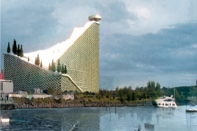
The International Competition to Designa New Waste to Energy Plant당선작 _ 아마게르포브랜딩Amageforbraending 신개념 폐기물 처리 시설BIG achitects(Architect) Realities United Interactive Facade), AKT Facade & Structural engineering), Topotek/Man Made Land (Landscape)
책임 _BIG architects(Bjarke Ingels, David Zahle)설계참여자 _ Brian Yang(Project leader), Jelena Vucic, Alina Tamosiunaite, Xing Xiong, Armor Gutierrez, Jakob Lange, Andreas Klok Pedersen,Maciej Zawadzki, Daniel Selensky, Gul Ertekin, Sunming Lee, Long Zuo, Ji Young Yoon
본 프로젝트의 목표는 이 모든 상반되는 요소들을 한 데 묶어 코펜하겐의 새로운 명소로서 아마게르포브랜딩의 정체성을 창조하는 것이다. 즉 사람들이 일부러 찾아올 수 있는, 그 자체로서 의미 있는 공간으로 탈바꿈시키는 것이다.
우리는 경제적, 환경적, 사회적 가치가 높은 신개념의 폐기물-에너지 변환 설비 모델을 제시하고자 한다. 아마게르포브랜딩을 별도의 고립된 대상으로 간주하지 않는 동시에, 건물에 생동감을 불어넣고, 도시와의 연계성을 강화하고자 한다. 새로운 아마게르포브랜딩의 지붕을 코펜하겐 시민들을 위한 스키 슬로프로 전환함으로써 주변 지역에서 펼쳐지고 있는 기존의 여러 활동들의 폭을 확장할 수 있을 것이다. 신개념 공장이 등장할 때가 된 것이다.The aim of the project is to tie all these opposing forces together, forming an identity for a new place in Copenhagen. We want to turn it into a place in itself - a destination where people will travel to.
We propose a new breed of waste-to energy plant, one that is economically, environmentally, and socially profitable. Instead of considering Amagerforbraending as an isolated object, we mobilize the architecture and intensify the relationship between the building and the city -expanding the existing activities in the area by turning the roof of the new Amagerforbraending into a ski slope for the citizens of Copenhagen. Now is time to re-brand the factory.
위치 _ Copenhagen, Denmark | 면적 _ Building 5,000m2, Landscape 90,000m2 Total Floor Area Roof+Ski Slope: 32,000m2, Facade Area 74,000m2, Administrative Visitor Center Floor Area 6,500m2 | 예산 _ 3,5 BLDKK(650 MO US$) | 발주 _ Amagerforbraending
-
 산야 올림픽 베이 국제 설계 공모전
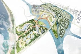
Sanya Olympic Bay International Competition008년 국제올림픽위원회(IOC)는 중국 산야시 하이탕 만에 위치한 133헥타르 부지에 마리나, 올림픽 메모리얼, 국제 회의장, 의료 시설, 스포츠 시설, 주거 시설, 리조트를 포함하는 올림픽 복합 시설을 건설할 계획을 승인하였다. 2�008년 베이징 올림픽을 기념하여 중국 정부와 하이난 성은 베이징 올림픽 성화 봉송의 시작 지점인 산야시에 메모리얼과 함께 올림픽과 연계된 복합 스포츠 관광 단지의 건설을 추진해왔고, IOC의 적극적인 협조를 약속받았다. 그리고 마침내 총 52억 위안화가 소요될 이 대규모 프로젝트를 위해 2010년 7개의 국제적 건축, 도시, 조경 설계회사들이 초정되어 국제 공모전이 실시되었고 SWA의 안이 최종 당선작으로 선정되었다.
SWA Group +DRDS설계참여자· SWA: 김영민(Youngmin Kim, Project Designer), Gerdo Aquino, Ying-yu Hung, 최영준(Youngjoon Choi), Alex Robinson, 이웅희(Woonghee Lee), 박나라(Nara Pak), Carlos E. Hernandez· D�RDS(Architecture): Paul Quinn Davis, Steven Ryder, Peter Samarin, Daniel Carper
-
 다크 리프트
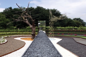
Dark Rift Ponte de Prima International Garden Festival 2010심사위원 선정 1위 수상, 공공 부문 2위 수상2005년 이래로 포르투갈의 유서 깊은 도시 폰테 드 리마Ponte de Rima에서는 매년 6개월에 걸쳐 국제 정원 축제가 개최되고 있는데, 여기에는 건축가, 조경가, 그리고 예술가 등이 만든 비영구적 작품들이 소개되고 있다. 올해로 여섯 번째 열리는 이번 행사에는“정원의 카오스Kaos of the Garden”를 주제로 하였으며, 심사위원단은 자연과 인공 사이의 트랙을 보여준 PPil과 Oglo를 수상자로 선정하였다. 이 정원의 시공팀은 국립 베르사유 고등 건축학교ENSAV에 재학 중인 건축학 전공 학생들로 구성되었으며, Oglo와 PPil은 시당국의 협조를 빌어 작업을 감독했다.
Since 2005, the oldest city in Portugal, Ponte de Lima, host every year during 6 month, an international garden festival, made of ephemeral works made by architects, landscaper and artists. For the 6th edition with the theme “aos in the Garden” Oglo associated with PPil were selected by the jury. The project Dark Rift-a track between natural and artificial have been selected among 77 proposals submitted from15 country. The garden’ construction team was formed of architecture students of Ensav-Ecole Nationale d’rchitecture de Versailles. With the help of Municipality people, Oglo and PPil supervised the garden’ workshop.Architects _ Oglo + PPilProject Team _ Emmanuel de France, Arnaud Dambrine, Sébastien Demont, Hortense Reynaud Production Team _ Emmanuel de France, Arnaud Dambrine, Sébastien Demont, Anne-Claire Lemaignen, Pauline Soethoudt, Thaïs de Roquemaurel, Pauline Rabjeau, Marine Demandre, Aymeric Lebon, Damien Poirier,Johann van den Hende, Baptiste Chamourat, Augustin Caradec Workshop partners _ Ecole Nationale Supérieure d’rchitecture de Versailles, K’et, Architec’onicClient _ Municipio de Ponte de LimaCompletion _ 2010Location _ Ponte de Lima, PortugalArea _ 250㎡Editor _ Kim, Se YoungEditoral Designer _ Lee, Eun MiTranslator _ Ahn, Ho KyoonPhotographers _ Arnaud Dambrine & Emmanuel de France
-
 선전시 테크놀로지 파크
Shenzhen Technology Park공지가 전혀 없는 도시 내 블록은 어떻게 하면 혁신적이고 매력적인 공공 부분으로 탈바꿈시킬 수 있을까?중국 선전시 사우스힐에 위치한 선전 테크놀로지 파크Shenzhen technology park는 낙후된 사무용 건물들과 신축 건물들이 공존하는 비좁고 무질서한 공간에 자리 잡고 있다. 복잡한 지형, 비정상적인 위치 정보 그리고 엉망인 주차 시스템 등은 비단 이곳에서 뿐만 아니라 중국에서는 매우 보편화된 도시 공간의 특성이다. 본 프로젝트의 목표는 실용적이고, 긍정적인 동시에 매력적인 도시 공공 공간을 조성하는 것이다.본 프로젝트의 핵심으로는 독특한 모양의 수조 및 화단과 그 위에 세워질 굽은 형태의 교량을 들 수 있다. 차량 통행은 교량 위의 메인 도로가 맡게 된다. 교량 아래로는 햇빛과 그림자가 어우러져 새로운 발견의 가능성을 한 폭의 그림으로 완성한다. 교량 위의 공간은 통행용 도로와 여가 공간으로 각각 나누어진다. 동시에 사람들도 경관의 일부가 되어 극적인 장면을 연출하게 된다.
The site without open space being one of city blocks, how it becomes inventive and attractive public space?The compression of the ShenZhen technology park project located SouthHill, Shenzhen, in the narrow and disorder space between old office blocks and both with new buildings. With complicated contours, abnormal field identification, messed up parking system, the site being very common city space in China. It is aimed to create practical, positive and charming urban public space.The premises of design generate a bended bridge embed in unusual-shape water container and planters, become main scene in the agro. The flows of transportation rely on the mainstream path on the bridge, articulating pieces of space. Under the bridge, sunshine is brushed up into shadows, drawing the possibility of discovery. On the bridge, space divided into two scales, which related to the function of path way and the rest to be leisure space.Simultaneously, people might become the part of scene, dramatically watching.Landscape Architecture _ TurenscapeChief Designer _ Pang WeiProject Manager _ Zhang JianWork Team _ Wei Min, Li Jin, Zhang Guiping, Fang Zheng, Xu Jie, Ruan Liuzhi, Yu aoClient _ Genzon GroupLocation _ Shenzhen, Guangdong, ChinaArea _ 22,705.1m2Completion _ 2008Translator _ Ahn, Ho KyoonPhotographer_ Wang Gen, Huang Zhijian, Luo Xiang
-
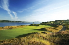 챔버스 베이 골프 코스와 사운드뷰 트레일
Chambers Bay Golf Course and Soundview Trail2008 ASLA Honor Award워싱턴 주 유니버시티 플레이스에 위치한 챔버스 베이 골프 코스와 사운드뷰 트레일은 2마일(약 3,218m)에 걸쳐 시야가 훤히 트인 푸젯 해협의 해안가에 위치하고 있다. 챔버스 베이는 환경을 고려한 설계, 계획, 건축을 통해 기존의 황량한 자갈 채석장에서 전 세계와 북서부에 거주하는 골퍼들에게 화젯거리가 된 세계적으로 유명한 골프 코스와 트레일 시스템으로 변모되었다.
Chambers Bay Golf Course and Soundview Trail of University Place, Washington sit on two miles of uninterrupted Puget Sound Shoreline. Utilizing environmentally conscious design, planning and architectural practices, Chambers Bay was transformed from a desolate gravel quarry into a world renowned golf course and trail system that is quickly becoming the talk of golfers worldwide and Northwest residents alike.Landscape Architecture _ GCH Planning & Landscape ArchitectureClient / Owner _ Pierce County WashingtonGolf Course Architects _ Robert Trent Jones II, LLCCivil Engineers _ AHBLEnvironmental Consultants _ Audubon InternationalArchitects _ Miller Hull / CHAContractor _ Heritage LinksGolf Course Operator _ Kemper SportsGolf Course Maintenance _ David Wienecke, Turf care teamLocation _ University Place, Washington, USASize _ 360 acre(50 acres of park and 3 miles of trail)Completion _ 2008Translation _ Hwang, Ju YoungPhotos _ Aidan Bradley
-
 스힌켈 아일랜드
Park Schinkel Islands스힌켈 섬스힌켈 구역은 스힌켈 운하를 따라 있는 지구이다. 암스테르담 변두리에 위치한 이 구역은 수많은 레크리에이션 시설이 수용된 네 개의 섬이 모인 군도로 알려져 있다. 설계의 근간은 오래된 기차 탑승장을 활용하여 폰델 공원과 암스테르담 숲 사이를 위락적이면서도 생태적으로 연결하는 것이었다.테니스장 섬, 보트 창고 섬, 축구장 섬, 공원 섬, 자연 섬 등 다양한 기능을 테마로 각 섬의 성격이 결정되었다.물이 점유한 공간을 확장하고, 부두와 플랫폼, 다리와 갈대밭을 활용하여 물의 존재가 보다 직접적으로 느껴지도록 하였으며, 암스테르담 시로 들어가는 새로운 입구를 형성하는 독특한 수상공원이 되었다.
The Schinkel zone is an area along the Schinkel channel located on the fringe of Amsterdam.The zone is interpreted as an archipelago existing of four different islands that house a large number of recreational facilities. The backbone of the design is a recreational and ecological connection between the Vondel park and the Amsterdam Forest, using an old railway embankment. The various functions determine the nature of the islands: there is a tennis island, an island of boat houses, a soccer island, a park island and a nature island. By increasing the total area of water andusing piers, platforms, bridges and reed beds, the presence of water is felt more directly.The area becomes a unique Water Park forming a new entrance for the city of Amsterdam.Designers _ Buro Sant en Co, Edwin Santhagens, Wim van KriekenLocation _ Amsterdam, The NetherlandsClient _ Municipality of AmsterdamCompletion _ 2008Translation _ Hwang, Ju YoungPhotos _ Buro Sant en Co
-
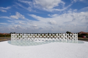 카살그란데 세라믹 클라우드
Casalgrande Ceramic CloudKengo Kuma and Associates가 의뢰받은 것은 훌륭한 도자기 전통과 그 기술로 유명한 레지오 에밀리아(Reggio Emilia) 지역의 카살그란데(Casalgrande)에 있는 회전 교차로에 기념물을 설계하는 것이었다. 이 회전 교차로는 레지오 에밀리아 지역의 아름다운 경관으로 둘러싸여 있다.도자기 타일을 기존의 단순한 외장 피복재로서 사용하는 것이 아니라 건축적 요소로 이용해 보기로 했다. 규격화된 도자기 타일을 이용한 장식방법과 이 타일들을 연결시키는 방법에 대한 구체적인 상세도를 그려본 후에야, 이 타일들로 다양한 구조를 조립하고 조작할 수 있는 방법에 관한 몇몇 가능성을 파악할 수 있었다.단순히 부지의 중앙에 세워진 기념물을 만들어내는 것이 아닌 구조물 자체가 부지의 일부가 되기를 원했다. 이러한 이중적 특성을 지니면서 부지를 두 개의 공간으로 분리하는 벽체를 고안했는데, 이는 흔한 형태의 지극히 평범한 회전 교차로와는 거리가 먼 형태였다.이러한 탈 기념비적 접근 방식은 길과 도자기 타일 벽체를 나란한 방향으로 두는 시도를 할 만큼 충분한 것이었다. 그 장소에 도착했을 때 비로소 운전자들은 수직적인 선으로 나누어진 회전 교차로를 인식하게 된다. 자동차의 움직임에 따라 회전 교차로를 돌아서면, 벽은 45m의 전체 길이를 드러낼 때까지 연장된다.We were asked to create a monument in a road roundabout in Casalgrande, an area of Reggio Emilia known for its great tradition and technology for ceramics. This roundabout is surrounded by the beautiful landscape characteristic of that part of Italy.
We took the challenge of involving the ceramic tile as an architectural element itself, avoiding its conventional use as a mere cladding.
Just after developing a specific detail of how to panel and connect standard ceramic tiles, we understood the possibilities of how to assembly and organize them creating different structures.
With this unique structure we wanted to avoid creating a monument that stands in the middle of the site: we wanted it to become part of the site. Therefore we decided to create a wall that simply divides the site in two making it a special place with a dual character, far from the usual and banal roundabouts. Our anti-monumental approach went far enough to decide aligning the direction of the ceramic wall with the road that leads to it so as to make it almost disappear: when reaching the site, drivers will only perceive a roundabout divided by a vertical line. Only when going around it, along the movement of the car the wall extends until appearing with its whole length of 45 meters.
In our buildings we usually work with concepts of anti-dimension or anti-volume but in a project like this with such an especial site (a roundabout only approachable by cars) we wanted to experiment on these concepts’ relationship with dynamic principles such as time, movement and sequential perception.
Seeing this wall growing during its months of construction, we realized how dynamically its light structure’s transparency and the subtle reflection of its fine glazed white ceramic where interacting with the surrounding site and the weather. This other way of dynamism appeared to us as a very unique soft, light and ever-changing phenomena… and that is why we have called it Ceramic Cloud.Architect _ Kengo KumaClient _ Casalgrande Padana S.p.a.,Location _ Casalgrande, Reggio Emilia, ItalyArea _ 2,826㎡Material _ Unglazed stoneware slabs(1,200×600×14㎜), Stone, SteelCompletion _ 2010. 9.
- http://kkaa.co.jp / 2011년06월 / 278
-
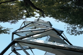 무어강 전망대
Observation Tower on the River Mur형태, 운동, 구조의 상호작용오스트리아 남부 스티리아 주의 무어강에 새로 들어선 전망대는 2010년 봄의 시작에 맞추어 개장했다. ‘그린벨트’라 불리는 유러피언 해비타트 시스템의 풍경 속에 설치된 이 조각적인 구조물은 뮌헨을 거점으로 활동 중인 건축, 조경 그룹인 terrain:loenhart&mayr이 설계하였다. 무어강의 둑에서 바라보면, 전망대는 주변 범람원 숲을 둘러싼 생태를 접하게 해 줄 뿐만 아니라 물 흐름의 세기에 따라 달라지는 집수구역을 체험하게 해준다.
무어 타워의 접근 원리 및 구조 원리는 나무를 따라 올라가는 연속적인 길로 여겨지는 이중 나선 구조의 개념에 기초를 두고 있다. 정상을 향해 오르는 방문객들은 경관을 체험하게 된다. 나사못처럼 정상부를 향해 원형으로 돌아가는 통로는 범람원 숲의 생태적 다층 구조를 이루는 여러 층을 지나며 방문자들이 숲의 생태계와 미기후를 경험할 수 있도록 해준다.마침내 168개의 계단을 오르고 나면, 높이 27m의 전망대에 도달할 수 있다. 이 계단은 의도적으로 조금씩 작아지며 인근 전원지역의 아름답고 파노라믹한 경치를 느끼게 해준다. 두 번째 계단은 전망대로부터 아래쪽으로 이끄는데, 오르거나 내려가려는 방문객들은 반대편 계단의 제한된 공간 때문에 사실상 이곳으로 움직인다.
구조 계획가들과의 협업을 통해 다변형의 형상을 가진 공간 구조가 전개되었는데, 이는 구조와 제작 기술과 관련된 모든 측면을 고려한 것이다. 의미 있게도 이러한 통합적 접근 방식은 스터디 모델을 준비한 뒤, 물리적 모델에 대한 건축적 관점의 점검을 통해 다시 한 번 디지털 영역에서 고정된 수치로 모델을 디자인 하는 등 설계 과정 전반에 걸쳐 적용되었다. 이 과정은 형태, 운동, 구조의 상호작용이 성립될 때까지 여러 차례 반복되었다.Interplay of form, motion and structure The new observation tower on the River Mur (Southern Styria, Austria) opened to the public just in time for the beginning of spring 2010. The design for the sculptural structure set amidst the landscape of the European habitat system “Green Belt” was developed by the Munich-based architects and landscape architects, terrain:loenhart&mayr, who are renowned for the new and trend-setting Olympic Ski Jump in Garmisch-Partenkirchen. With the look-out on the banks of the River Mur, the observation tower offers access to the ecology of the surrounding floodplain forest and lets visitors experience the river catchment, which changes according to the intensity of the water’s flow.
The access and construction principle of the Mur Tower is based on the idea of a double helix that is perceived as a continuous path rising up through the trees. The visitors’ climb to the top is a scenic experience. The circular path, ascending to the top like a screw, passes through the different levels of the forest ― the ecological storeys of the floodplain forest ― and enables visitors to experience the eco system and the microclimate of the forest. Eventually, after 168 steps, at a height of 27m, the observation platform is reached. This was deliberately kept small and offers wonderful panoramic views of the surrounding countryside. A second flight of stairs leads down from the platform so that ascending and descending visitors are actually moving through the defined space on different flights of stairs.
There is a surprising link to the historical double spiral staircase in Graz Castle. The architects of the Mur Tower were inspired by that staircase built around 1500 and well known for the unique spatial atmosphere it creates. In a homage to this historical site, the Austrian poet, Erich Fried, wrote that “the double spiral staircase connects space and time like a screw”. The connection between space and the experience of climbing up and down is the basic idea behind the spiral-shaped paths of the Mur Tower.
In collaboration with the structural planners, a polygonalised spatial structure was developed, which took into account all aspects relevant to the structure and the technical production. Significantly, an integrated approach was adopted for the design process ― after some preliminary model studies were prepared, the model designs were statically dimensioned in digital domains to then once again be checked from an architectural point of view in physical models. This process was repeated several times until the desired interplay of form, motion and structure was established. Design+planning of tower and exteriors _ terrain:loenhart&mayr architects and landscape architects, Munich/GrazStructural planning _ osd - office for structural design, FrankfurtClient _ Gemeinde Gosdorf Orts- und Infrastrukturentwicklungs KGLocation _ “Grunes Band”- European Nature Reserve, Gosdorf, Styria, AustriaOpening _ 2010. 3. 20
- http://terrain.de/cms / 2011년06월 / 278