
월간 환경과조경 검색 결과
선택 조건으로 총
2,353개의 게시물이 검색되었습니다.
- 카테고리: FEATURE
-
 연평균 10.8건의 범죄 발생. 도시 내 우범지대가 아니다. 우리들 집 앞 공원에서 벌어지고 있다. 거의 매달 한 건 꼴이다. 그 종류도 다양하여 폭력을 비롯한 온갖 도시형 범죄들이 모두 들어있다. 그동안 CCTV 같은 감시 장치와 조명등이 많이 보강되었고, 예방을 돕는 휴대폰을 누구나 다 갖고 있는데도 범죄 발생률은 꺾이지 않고 있다. 문명이 발전할수록…
 -
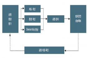 공원의 안전성능안전한 공원 환경 조성을 위해서는, 시민의 이용이 적고 실제 범죄발생 빈도가 높았던 야간시간대의 범죄를 예방하기 위해 야간 조명시설 및 방범시설 설치 증가, 순찰활동의 강화 등이 있을 수 있다. 특히 심야시간의 범죄발생빈도를 줄이기 위해 공원 출입시간의 통제 방안도 검토할 필요는 있으나, 우리나라의 사정상 근린공원이나 아파트 단지 주민들이…
 -
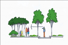
 누구나 특별히 가고 싶은 공간, 누구와 함께하고 싶은 공간, 소중한 사람을 데려가고 싶은 공간, 추억을 만들고 싶은 공간이 있다. 사회에 존재하는 공적인 공간이 이러한 공간이면 더할 나위 없이 좋을 것이다. 특별히 고도로 복잡하고 체계적인 범죄예방 프로그램을 적용하지 않아도 사람을 중심으로 한 공간 사용방식만으로 충분히 안전한 공간이 될 수 있다…
 -
우리 사회는 범죄로부터 안전한가?우리 사회는 범죄로부터 안전한가? 시민들은 여전히 안전한 삶에 대한 자유와 권리를 보장받고 있는가? 범죄로부터 안전한 환경은 무엇인가? 인간의 동기부여에 관한 욕구를 5단계로 구분한 미국의 심리학자 매슬로우1908~1970는 인간의 가장 기본적인 욕구가 의식주의 문제를 해결하고자 하는 생리적 욕구이며, 이 욕구가 어느 정도…
-
 한국셉테드학회 범죄예방 환경설계 인증 개요2010년 3월 창립된 (사)한국셉테드학회(Korea CPTED Association)는 건축물과 도시공간 유형별로 적용할 수 있는 범죄예방 환경설계 평가기준을 개발하여 ‘범죄예방 환경설계인증’제도를 시행하고 있다. 범죄예방 환경설계 인증은 (사)한국셉테드학회 산하 ‘셉테드 인증센터’의 범죄예방 환경설계 인증에…
 -
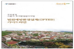 현재 서울시에서는 18개의 주거환경관리사업이 CPTED 가이드라인을 적용하여 진행 중이지만 주거환경관리사업이 도입된 지 얼마 되지 않아 공사가 준공된 지역이 아직 없기에 현재 기본계획 완료 후 실시설계가 먼저 진행 중인 온수동 사례를 간략히 소개하고자 한다. 기존에 범죄예방 환경설계가 신축 건축물 또는 대규모 단지 개발에 적용되어 온 점에 반해…
 -
 CPTED 인증을 추진하고 있는 배곧 신도시송도 신도시와 마주하고 있는 시흥 군자 배곧 신도시는 경기 서부권 개발가능지의 최후의 보루이자 서해의 시화공단, 오이도, 월곶, 소래철교, 천혜의 소래염전 갯골생태습지를 안고 있는 시흥시 정왕동 일원의 부지면적 4,907,148㎡에 이르는 대규모 개발지역이다. 이곳에 전체의 21.9%가 주거 및 주상복합용지로…
 -
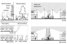
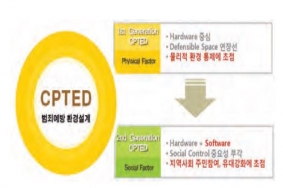
 2005년 9월 경찰청에서는 “환경설계를 통한 범죄예방계획(CPTED:Crime Prevention Through Environment Design)에 대한 구체적인 실행방안을 발표한 바가 있다. ‘CPTED’란 주거 환경설계에 방범개념을 도입하여 범죄와 범죄에 대한 주민들의 두려움을 감소시켜 궁극적으로 모든 사람들이 범죄없는 환경에서 편안하고 행복한…
 -
Gardens in Suncheon Bay Garden Expo 2013물을 담는 큰 그릇 K-Water Garden _ 최윤석((주)그람디자인)하나씨드뱅크가든 Hana Seed Bank Garden _ 오경아(오가든스)색, 펼치고 개다 The Color, Open and Close _ 김연금(조경작업소 울)SK 행복정원 Steps Towards to…
-
순천만국제정원박람회가 순항 중이다. 4월 20일 개장 이후 13일 만에 50만 명을 돌파했고, 26일째인 5월 15일에는 100만 명을 훌쩍 넘어섰다. 원래 목표는 방문객 400만 명이었다. 그러나 지금 추세라면 600만 명에 이를 것으로 점쳐지고 있다. 방문객이 몰리는 여름 휴가철이 있고, 가을에는 또 다른 색깔을 보이는 정원의 특성을 생각하면 무리한…