-
 리조트
리조트
-
 마리나 베이 샌즈 인테그레이티드 리조트
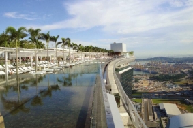
Marina Bay Sands Integrated Resort싱가포르섬까지 이어진 인공 간척지인 마리나 베이 반도 Marina Bay Peninsula에 위치한 마리나 베이 샌즈 인테그레이티드 리조트는 해당 지역 개발사업 전체를 아우르는 핵심적 프로젝트로서, 향후 반도 전역에 걸쳐 진행될 모든 프로젝트를 위한 도심 경관 전략의 기준을 제시하게 될 것이다. 빌딩과 오픈 스페이스 등으로 구성된 방대한 규모의 이 콤플렉스는 싱가포르의 동남부 지역에 자리하고 있는데, 싱가포르만으로 접어드는 바다에서 바라봤을 때 마치 등대와 같은 구실을 할 뿐만 아니라 신규 개발지와의 연결고리로서의 역할을 담당하게 될 것이다. PWP는 싱가포르 최초의 종합 리조트 및 카지노 시설인 마리나 베이 샌즈에 대한 개발과 더불어 이 지역을 도시 전역과 연결해줄 공공 공간에 대한 개발을 동시에 진행하였다. 전체 프로젝트는 Singapore Garden City Framework 및 Singapore Green Plan의 기조를 적극 반영했는데, 이를 통해 지속가능성과 도시 녹화라는 싱가포르 정부의 두 가지 커다란 목표에 기여하게 된다. 2011년 본 프로젝트의 완성을 통해 30여 년 전 간척사업으로 시작된 싱가포르의 영토확장 사업이 첫 결실을 맺게 되었다. 향후 이 지역이 보다 활기를 띄게 되면 싱가포르 정부는 더 많은 건설 부지를 민간에 할당해 마리나 베이 샌즈와 기존 도심지역 사이의 공간에 활발한 개발이 이루어지도록 할 것이다. 조경은 일시적인 제약 요건 및 신규 건축물을 위한 구조적 장치로서 매우 중요한 역할을 담당해왔다.
Landscape Architecture _ PWP Landscape ArchitectureLansdcape Design Team _ Peter Walker/FASLA, AdamGreenspan, Julie Canter, Su-Jung Park, Conway ChangArchitecture _ Safdie ArchitectsLandscape Architect of Record _ Peridian AsiaArchitect of Record _ Aedas Pte LtdEngineers _ Ove Arup & PartnersLighting _ Project Lighting DesignClient _ Las Vegas SandsLocation _ SingaporeCompletion _ 2011Photograph _ PWP Landscape Architecture, Timothy HursleyEditor _ Son, Seok BeomTranslator _ Ahn, Ho Koon
Located on the Marina Bay Peninsula, a manmade land-fill expansion to the island of Singapore, the Marina Bay Sands Integrated Resort is the keystone project, defining and setting standards for the urban landscape strategy of all future projects on the Peninsula. The remarkable complex of buildings and open spaces designed for the southeastern edge of the city of Singapore act as an anchor to the new territory as well as a beacon from the sea at the entrance into Singapore Bay. PWP worked on both the Marina Bay Sands, Singapore’s first integrated resort andcasino, and on the simultaneous development of the public open spaces that will both define and connect this new district to the entire city. The entire project is within the Singapore Garden City Framework and the Singapore Green Plan, whichsupport the city wide goals of both sustainability and greening. The completion of this project in 2011 represents the first built project in a planned expansion of the city of Singapore that began over 30 years ago through landfill efforts. As the area becomes more active over the coming years the government plans to release additional building sites, allowing further development to infill between the Marina Bay Sands and existing downtown Singapore. Landscape has played a critical role as both a temporary condition and a structuring device for new buildings.
-
 사우스 파크 개발
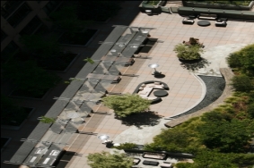
South Park Development마스터플랜을 완성하는 과정에서 추구한 바는 가로경관과 오픈 스페이스를 통해 커뮤니티와 지속가능한 삶의 방식을 명시적으로 보여줄 수 있는 새로운 마을을 개발하는 것이었다. 이러한 디자인 철학을 바탕으로 최초의 로스앤젤레스 도심의 녹색 가로Green Street for Downtown Los Angeles와 이웃 간의 교류를 촉진시켜줄 오픈 스페이스 디자인이 탄생하게 되었다.
로스앤젤레스 중심업무지구Downtown Los Angeles 내 4개 블록에 걸쳐 위치한 프로젝트 대상지는 현재 Evo, Luma, Ellevan으로 불리고 있는 복합 용도의 LEED 인증 Gold 등급 빌딩 3개동, 가로경관, 그리고 각각의 건물에 부속된 공용의 오픈스페이스 등으로 구성된다. South Park라는 이름으로 통칭되는 해당 지역은 South Group Development에 의해 건설되었으며, 이곳은 이 회사가 미국 서부 해안지역에서 진행하고 있는 미래지향적이며 생태친화적인 건설 포트폴리오의 한 부분을 차지하고 있다.
가로경관 디자인은 로스앤젤레스에 있어 매우 독특한 성격을 지닌다. 가로경관 해당 블록 전체를 촘촘히 에워싸는 동시에 보행자들의 다양한 활동을 촉발시킴으로써 새로운 공동체 의식을 고취하도록 고안되었는데, 사람들이 쉬어갈 수 있도록 그늘이 드리워진 벤치를 마련하고, 옥외 식사가 가능하도록 노변에 카페를 조성하는 등의 아이디어를 활용했다. 보행자의 안전이 최우선 고려사항이었으며, Curb extension, 보행자용 가로등, 건널목 등을 디자인에 포함시켜 보행자의 안전을 도모하였다.Landscape Architecture _ AHBE Landscape ArchitectsArchitects _ GBD Architects, Ankrom Moisan,TVA Architects, Inc.Developer _ South GroupLocation _ Los Angeles, California, USAArea _ 58,250㎡(Evo), 26,849㎡(Luma), 37,161㎡(Elleven)Completion _ 2008Editor _ Son, Seok BeomTranslator _ Ahn, Ho KyoonWorking from the master plan to completion, AHBE worked to develop this area into a new neighborhood that exemplifies community and sustainable living through streetscape and open spaces. The design resulted in the first Green Street for Downtown Los Angeles and an open space design to promote neighborhood interaction.
Located in a four block area in the South Park neighborhood of Downtown Los Angeles, the project consists of three mixed-use LEED Gold certified buildings (now known as Evo, Luma, and Elleven), the streetscape, and a common open space area associated with each building. We designed the streetscape and open space areas (as well as the residential amenity decks). Collectively, the site, known as South Park, was built by the South Group Development and is part of their forward-thinking and eco-driven portfolio of work, being built throughout the West Coast.
Our streetscape design is unique to Los Angeles. It wraps around the block and was designed to create a new sense of community by encouraging pedestrian activity around the area, leaving space for outdoor eating for sidewalk cafes as well as shaded benches to encourage lingering. Pedestrian safety was a high priority to our team and we included curb extensions, pedestrian lighting, and crosswalks to increase pedestrian safety.
-
 토레블랑카 파크
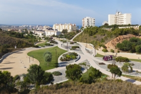
Torreblanca Park이 지역은 토레비야Torrevieja시의 무분별한 성장의 결과로 나타나게 된 잉여의 버려진 땅이다. 해당 지역 전역에 걸쳐 표고차의 변화폭이 크기 때문에 매우 복잡한 건축설계가 필요하다. 프로젝트는 경사면에 소나무를 식재하고 이 나무들이 숲을 이루도록 한 뒤 저지대로 이어지는 여러 개의 작은 길을 만드는 것을 골자로 한다. 이러한 길은 향료식물을 재배하는 묘목장을 휘감아 돌고, 길가에는 덩굴식물이 타고 올라갈 수 있는 철재 격자 구조물이 설치되기도 한다.우리는 이 정원이 향기로 가득차 비탈진 길을 따라 아래로 내려오면서 그 향기에 매료될 수있기를 기대했다.Design _ Carme PinosLocation _ Alicante, SpainArea _ 2,000㎡Completion _ 2010Photograph _ David CabreraEditor _ Park, Sang BaekTranslator _ Ahn, Ho Kyoon
It is a marginal lot, leftover from the uncontrolled growth of Torrevieja. The strong contour change in both sides of the lot makes the construction very complicated. The project consists in replanting with pine trees the slopes, turning them into a forest where small paths go down to the lower level. It is at this level where the paths entwine aromatic planting beds, always in circles. Sometimes these circles get volume, We wanted our garden to be a concentration of perfumes in which we are submerged as we descend.
-
 사이드 이펙트
Side Effect
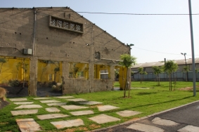
‘사이트 이펙트’가 위치한 대상지는 도시의 거주지역과 공업지역의 경계선상, 즉 ‘중간’지대라고 부를만한 곳에 있다. 이 지역은 도시계획의 목적에 부합하지 못하여 버려졌다. 대상지 자체는 콘크리트 담장과 철조망으로 둘러싸인 건물들로 이루어져 있다. 프로젝트 이전에 버려진 건물 골조는 주변의 주민과 사업주들의 쓰레기장으로 쓰여 인근 자동차 정비소에서 나오는 폐기물을 포함한 쓰레기로 가득했다. 대상지 주변에는 공업시설과 주거시설, 고등학교와 신학교, 제지공장, 몇 개의 작은 상점이 있다. 계획에는 공업지역과 주거지역 사이에 다리를 놓고자 했다. 대상지의 건물 골조가 작업의 기초가 되었으며, 구조를 축소하고 주변의 부가적 공간을 규정하여 새로운 대상지가 만들어졌다. 석면 지붕을 제거하자 인상적인 철골 구조물이 드러났다. 내벽은 안전상의 이유로 제거되었고, 외벽에 새로운 문을 몇 개 만들어 건물을 주변과 연결했다. 뿐만 아니라 대상지를 거리와 건물로부터 차단하던 철조망을 높이 올린 콘크리트 담장도 제거되었다. 이 콘크리트는 얇게 잘려 대상지의 새로운 입구를 경계 짓는 수평면을 만드는데 재사용되었다.Design _ Amir Lotan, Landscape ArchitectLocation _ Intersection of Ort Israel and Melacha Streets,Bat Yam, IsraelArea _ 2,000㎡Completion _ 2010Photograph _ Ben HerzogEditor _ Park, Sang BaekTranslator _ Hwang, Ju YoungThe site on which ‘Side Effect’ is located is at the fault line between the city’s residential and industrial areas, in what can be called an ‘intermediate’ zone. The area does not fulfill its purpose, according to the city’s plan, and is therefore abandoned. The site itself comprises of a building, surrounded by a concrete wall and barbed wire. Prior to the project, the abandoned building skeleton was used as a dumping ground by the surrounding residents and business owners, filled with refuse material including that from a nearby garage. The site is bordered by industry and residences and public facilities including a high school, a religious school, a paper mill and a few small stores. In my plan, I tried to create a bridge between the industrial zone and the residential one. The building skeleton at the site was the basis of the work. By paring down the structure and defining additional space around it, a new site was created. After the removal of the Asbestos roof, an impressive steel construction was exposed. The interior walls were dismantled for safety reasons and some new openings were created through the external walls, so as to connect the building with its surroundings. Furthermore, another concrete wall with an elevated wire fence that originally blocked the site from the street and buildings was removed. The concrete was then sliced up and recycled to form a horizontal plane that defines a new entrance to the site.